Notes re various parish missions and retreats given to lay sodalities and local parishioners. The notes were compiled by Fr. Fidelis Neary OSFC (1855-1932). The notes refer to missions given by Fr. Fidelis and other friars in Counties Cork, Kilkenny, Waterford, Longford, Galway, Dublin and elsewhere. Some of the more detailed descriptions refer to the effects of Parnellite split and political disputes upon the populace and mission attendees, and to hostilities with local Protestant landed proprietors. The notes include:
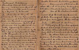
• Mullinavat, County Kilkenny. Apr. 1892: ‘A most memorable week. Commenced by a “Boycott” by the Parnellists …’.
• Glenmore, County Kilkenny. June 1893: ‘The Parish of Glenmore, like Mullinavat, was badly infested by Parnellism, a “Boycott” was worked up by the “Hog boys” of Ballybricken, Waterford, with Hogs’ Band etc. On hearing of the happy results in Mullinavat, the project was abandoned, and a public meeting held after Mass the previous Sunday withdrawing all opposition to the retreat and resolving to attend it. … Thus end[ed] the Parnell division in South Kilkenny’.
• Castlecomer, County Kilkenny. June 1894: ‘One of the most remarkable incidents of the week was the arrival of Father Prendergast, the famous Parnellite priest, from Urlingford …’.
• Church Street, Dublin, July 1894: ‘A retreat for the members of the Sacred Heart Sodality commenced in the above Church on Sunday night, July 22nd and concluded [on] Sunday night, 29th. The above retreat was not a success, but rather a poor business. Couldn’t be otherwise owing to majority of members and almost all leading members [had] rabid Parnellite tendencies. They didn’t attend and didn’t allow others attend. Fr. Francis Hayes OSFC had charge of the Sodality at the time’.
• Douglas, County Cork, July 1894: ‘Peculiarities of retreat were many, the most serious, the unnatural hour of morning devotions. … Some who had to come a distance had to get up at ¼ to 4am. Yet, notwithstanding two sledgehammer appeals, proprietors would not yield or allow one hour in the morning. Alleged excuse – the “Protestants at work would lose ¼ day and could not understand it”’.